|
|

     |
 |
The Caere Project concentrates on combining archaeological data
- taken from surveys, excavations, laboratory analyses and documentary
research - with methods developed at the Institute over many years
of experimentation with computer applications in archaeology (the
publication of the journal Archeologia e Calcolatori is direct
evidence of this research activity). From an archaeological point
of view, the project has been designed to incorporate data with
various levels of detail, ranging from the analysis of the surrounding
territory to the detailed level of excavation, in order to gain
a comprehensive and complete knowledge of the ancient landscape
and the organisation of the Etruscan town. In the development
of the project, subsequent operational stages have been designed
to investigate the following: formalising procedures, integrating
different systems, standardising technical and methodological
tools, and normalising the descriptive language.
 click to enlarge
 |
|
Since
the outset of the project, a great deal of attention has
been devoted to discussing the methodological and technical
issues specific to the research, to form a framework for
data acquisition and processing. The first stages of data
description and representation have therefore focused
on defining data models, aimed at outlining the formation
of archaeological data. The ability to clearly communicate
the results has been also central to the ideology of the
project, in order to experiment with innovative methodologies
of integration, information retrieval and the ability
to query excavation data and then use the Internet as
a new medium for the electronic publication of archaeological
data.
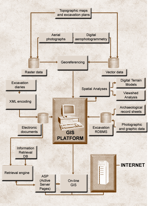
The process towards integration has been achieved by constructing
a relational database and its link with a multimedia system.
At the core of the framework is a GIS platform which provides
a pivot around which data hinges. |
|
|
|