|
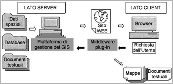
The Server is a program that provides
dynamic access to geographic and alphanumeric data through
an ODBC connection to the Author. It also manages the
security settings that have been established by the Author.
The front-end of the software, with which a user interacts,
is the Viewer. |
|
 The architecture of the on-line GIS
 |
It enables users not only to view data but also to interact with
the maps, modifying or querying theme layers.
In order to link the spatial data with the textual data, including
such information as grid location and structure type, an association
between the two will be created using ASP technology, already
employed for the textual retrieving system. Each entity, such
as an excavation grid, will be associated in the tabular data
with an URL address, containing ASP-generated codes linking directly
with the textual search engine. The results generated by this
query will be visualised as HTML documents.
MapGuide is highly suited for displaying archaeological data as
it can easily handle all the vector and georeferenced raster files
created in other systems. The limitation of this software in terms
of its GIS functionality is that it is not possible to conduct
complex spatial analysis or load surface interpolations, such
as TINs or viewshed maps, an important aspect of an archaeological
study. However, it is possible to separately provide 3D TINs generated
in ArcView across the Internet, through the use of the export
VRML format (.wrl). These models can be visualised by the user,
although it may be necessary to download a browser.